Geolocate

McAllen topographic map

Click on the map to display elevation.

About this map

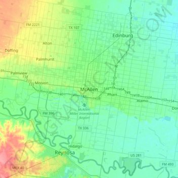
Name: McAllen topographic map, elevation, terrain.

Location: McAllen, Hidalgo County, Texas, 78501, United States (26.04437 -98.39008 26.36437 -98.07008)

Average elevation: 37 m

Minimum elevation: 21 m

Maximum elevation: 89 m

Gear up for your next adventure:

🗺️Topographic Maps - Detailed maps to explore trails, mountains, and wilderness areas
💧Reusable Water Bottle - Durable water bottles for hydration on trails
🥾Waterproof Trail Shoes - Shoes designed to handle wet terrain
🧦Outdoor Socks - Durable socks designed for hiking and outdoor sports
🐕Hiking Dog Pack - Let your canine companion carry their own water and food

As an Amazon Associate, this site earns from qualifying purchases at no extra cost to you.