
Huaylas topographic map
Click on the map to display elevation.
Huaylas
The district is located in the north-western part of the province at an elevation of 2,721m. The village of Huaylas is located 45 km from the city of Caraz.
About this map
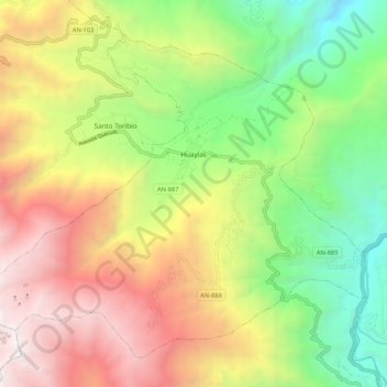
Name: Huaylas topographic map, elevation, terrain.
Location: Huaylas, Province of Huaylas, Ancash, Peru (-8.92747 -77.95099 -8.83857 -77.84489)
Average elevation: 3,145 m
Minimum elevation: 1,712 m
Maximum elevation: 4,898 m
Other topographic maps
Click on a map to view its topography, its elevation and its terrain.
Yerupajá
Based on the elevation provided by the available Digital elevation models, SRTM2 (6558m with voids), SRTM filled with ASTER (6551m with voids), TanDEM-X(6110m with voids), Yerupaja is about 6635 meters above sea level. This altitude was considered due to the lack of topographic data or even handheld GPS data.
Average elevation: 5,637 m