Geolocate

Monte Castillo topographic map

Click on the map to display elevation.

Monte Castillo

El monte Castillo es un monte ubicado en la sierra del Dobra, dentro del municipio de Puente Viesgo, en Cantabria, (España). Conocido por las cuevas de arte rupestre que alberga. Tiene 355 msnm de altitud.

About this map

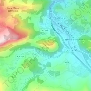
Name: Monte Castillo topographic map, elevation, terrain.

Location: Monte Castillo, Puente Viesgo, Valles Pasiegos, Cantabria, 39670, España (43.29062 -3.96918 43.29072 -3.96908)

Average elevation: 180 m

Minimum elevation: 54 m

Maximum elevation: 478 m

Gear up for your next adventure:

🥾Waterproof Hiking Boots - Essential footwear for rugged terrain and wet Canadian trails
🧥Waterproof Hiking Jacket - Protect yourself from rain and wind while hiking
🛌Down Sleeping Bag - Superior warmth-to-weight ratio for cold nights
🚲MTB Frame Bag - Carry tools and maps directly on your bicycle frame
🔨Vehicle Emergency Tool - Safety tool for remote road trips to trailheads

As an Amazon Associate, this site earns from qualifying purchases at no extra cost to you.