Geolocate

Cecima topographic map

Click on the map to display elevation.

About this map

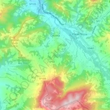
Name: Cecima topographic map, elevation, terrain.

Location: Cecima, Pavia, Lombardy, Italy (44.81420 9.04900 44.86830 9.09642)

Average elevation: 389 m

Minimum elevation: 222 m

Maximum elevation: 729 m

Gear up for your next adventure:

🛌Insulated Sleeping Pad - Critical thermal barrier between you and the cold ground
💡Solar Camping Lamp - Eco-friendly lighting for campsites
🔭Compact Binoculars - Lightweight optics for scouting trails and wildlife
🥫Freeze-Dried Meals - Lightweight, high-calorie nutrition for multi-day treks
🧢Sun Protection Cap - Breathable cap to protect from sun exposure

As an Amazon Associate, this site earns from qualifying purchases at no extra cost to you.