Geolocate

Bromham topographic map

Click on the map to display elevation.

About this map

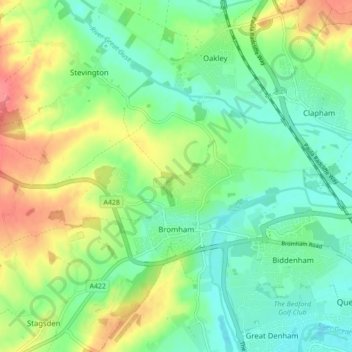
Name: Bromham topographic map, elevation, terrain.

Location: Bromham, Bedford, England, United Kingdom (52.13993 -0.57285 52.16633 -0.48601)

Average elevation: 50 m

Minimum elevation: 24 m

Maximum elevation: 95 m

Gear up for your next adventure:

🧦Thermal Socks - Warm socks for winter hiking or camping
🧢Hiking Sun Hat - Wide-brimmed protection for exposed mountain ridges
🧣Evaporative Cooling Towel - Beat the heat during intense summer climbs
🔨Vehicle Emergency Tool - Safety tool for remote road trips to trailheads
🥘Camping Cookware Set - Compact nesting pots and pans for trail cooking

As an Amazon Associate, this site earns from qualifying purchases at no extra cost to you.