Geolocate

Priañes topographic map

Click on the map to display elevation.

About this map

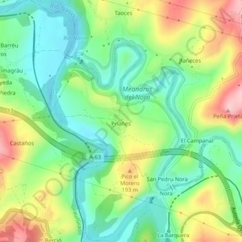
Name: Priañes topographic map, elevation, terrain.

Location: Priañes, Oviedo, Asturias, España (43.37451 -5.97189 43.37787 -5.96792)

Average elevation: 127 m

Minimum elevation: 55 m

Maximum elevation: 246 m

Gear up for your next adventure:

Camping Tent - Weather-resistant tents suitable for 2 to 6 people
🌡️Emergency Mylar Blankets - Compact thermal protection for unexpected nights outdoors
🦟Insect Repellent - Keep mosquitoes and black flies away in wooded areas
🩹Compact First Aid Kit - Pre-packed essentials for common trail injuries
🛏️Camping Sleeping Mat - Comfortable mats for sleeping outdoors

As an Amazon Associate, this site earns from qualifying purchases at no extra cost to you.