
Megilot Yam HaMelakh Regional Council topographic map
Interactive map
Click on the map to display elevation.
About this map
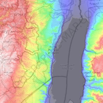
Name: Megilot Yam HaMelakh Regional Council topographic map, elevation, terrain.
Average elevation: 157 m
Minimum elevation: -415 m
Maximum elevation: 1,013 m
Other topographic maps
Click on a map to view its topography, its elevation and its terrain.
An-Nabi Musa
Palestinian Territory > Judea and Samaria > Area C > Megilot Yam HaMelakh Regional Council > An-Nabi Musa
Average elevation: -156 m