
Make a donation
Gear up for your next adventure:
As an Amazon Associate, this site earns from qualifying purchases at no extra cost to you.
Potchefstroom topographic map
Click on the map to display elevation.
Make a donation
Gear up for your next adventure:
As an Amazon Associate, this site earns from qualifying purchases at no extra cost to you.
Potchefstroom
Potchefstroom has hosted two World Cup-winning teams (in cricket and football), and is a home away from home for international athletes and teams. At 1,400 metres (4,600 ft) altitude, it provides a good balance between altitude and quality training. The city has no large factories, and good air quality. Athletes and professional teams train at the North-West University's High Performance Institute of Sport.
Make a donation
Gear up for your next adventure:
As an Amazon Associate, this site earns from qualifying purchases at no extra cost to you.
About this map
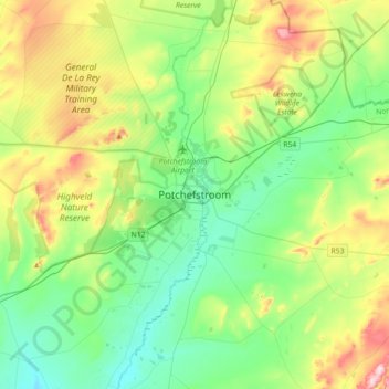
Name: Potchefstroom topographic map, elevation, terrain.
Average elevation: 1,393 m
Minimum elevation: 1,299 m
Maximum elevation: 1,614 m
Make a donation
Gear up for your next adventure:
As an Amazon Associate, this site earns from qualifying purchases at no extra cost to you.
Other topographic maps
Click on a map to view its topography, its elevation and its terrain.
Boskop Dam
South Africa > North West > Dr Kenneth Kaunda District Municipality > Tlokwe Local Municipality > Boskop
Average elevation: 1,399 m
Matlosana Local Municipality
South Africa > North West > Dr Kenneth Kaunda District Municipality
Average elevation: 1,414 m
Tlokwe Local Municipality
South Africa > North West > Dr Kenneth Kaunda District Municipality
Average elevation: 1,427 m
Matlosana Local Municipality
South Africa > North West > Dr Kenneth Kaunda District Municipality
Average elevation: 1,414 m
Make a donation
Gear up for your next adventure:
As an Amazon Associate, this site earns from qualifying purchases at no extra cost to you.
Maquassi Hills Local Municipality
South Africa > North West > Dr Kenneth Kaunda District Municipality
Average elevation: 1,335 m
Maquassi Hills Local Municipality
South Africa > North West > Dr Kenneth Kaunda District Municipality
Average elevation: 1,335 m