
Make a donation
Gear up for your next adventure:
As an Amazon Associate, this site earns from qualifying purchases at no extra cost to you.
Antalya topographic map
Click on the map to display elevation.
Make a donation
Gear up for your next adventure:
As an Amazon Associate, this site earns from qualifying purchases at no extra cost to you.
Antalya
The inland districts are high in the Taurus Mountains, at elevations approx 900–1000 m above sea level. These are; Gündoğmuş, Akseki, İbradı, Korkuteli and Elmalı.
Make a donation
Gear up for your next adventure:
As an Amazon Associate, this site earns from qualifying purchases at no extra cost to you.
About this map
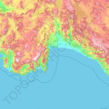
Name: Antalya topographic map, elevation, terrain.
Location: Antalya, Mediterranean Region, Turkey (36.09337 29.26204 37.42694 32.62709)
Average elevation: 681 m
Minimum elevation: -1 m
Maximum elevation: 2,937 m
Make a donation
Gear up for your next adventure:
As an Amazon Associate, this site earns from qualifying purchases at no extra cost to you.