
Make a donation
Gear up for your next adventure:
As an Amazon Associate, this site earns from qualifying purchases at no extra cost to you.
Koningshooikt topographic map
Click on the map to display elevation.
Make a donation
Gear up for your next adventure:
As an Amazon Associate, this site earns from qualifying purchases at no extra cost to you.
Koningshooikt
De Itterbeek is een kleine beek die uitmondt in de Nete ter hoogte van Duffel. Deze zorgde in 1998, 2014 en 2021 voor overstromingen.
Make a donation
Gear up for your next adventure:
As an Amazon Associate, this site earns from qualifying purchases at no extra cost to you.
About this map
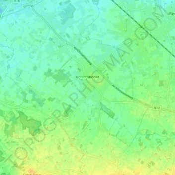
Name: Koningshooikt topographic map, elevation, terrain.
Location: Koningshooikt, Lier, Mechelen, Antwerpen, België (51.07267 4.54845 51.11305 4.64303)
Average elevation: 10 m
Minimum elevation: 1 m
Maximum elevation: 23 m
Make a donation
Gear up for your next adventure:
As an Amazon Associate, this site earns from qualifying purchases at no extra cost to you.
Other topographic maps
Click on a map to view its topography, its elevation and its terrain.