
Make a donation
Gear up for your next adventure:
As an Amazon Associate, this site earns from qualifying purchases at no extra cost to you.
Hoegaarden topographic map
Click on the map to display elevation.
Make a donation
Gear up for your next adventure:
As an Amazon Associate, this site earns from qualifying purchases at no extra cost to you.
Hoegaarden
Hoegaarden ligt op een hoogte van 42-108 meter. Het ligt aan de Grote Gete en tegen de taalgrens en het Waals Gewest aan.
Make a donation
Gear up for your next adventure:
As an Amazon Associate, this site earns from qualifying purchases at no extra cost to you.
About this map
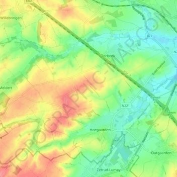
Name: Hoegaarden topographic map, elevation, terrain.
Location: Hoegaarden, Leuven, Vlaams-Brabant, Vlaanderen, 3320, België (50.76275 4.83115 50.81300 4.92429)
Average elevation: 71 m
Minimum elevation: 40 m
Maximum elevation: 111 m
Make a donation
Gear up for your next adventure:
As an Amazon Associate, this site earns from qualifying purchases at no extra cost to you.
Other topographic maps
Click on a map to view its topography, its elevation and its terrain.