
Moulin de l'Oule topographic map
Interactive map
Click on the map to display elevation.
About this map
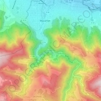
Name: Moulin de l'Oule topographic map, elevation, terrain.
Average elevation: 451 m
Minimum elevation: 223 m
Maximum elevation: 734 m
Other topographic maps
Click on a map to view its topography, its elevation and its terrain.
Le Moulin à Papier
France > Occitanie > Tarn > Mazamet > Hautpoul > Le Moulin à Papier
Le Moulin à Papier, Hautpoul, Mazamet, Castres, Tarn, Occitanie, France métropolitaine, 81200, France
Average elevation: 450 m