
Make a donation
Gear up for your next adventure:
As an Amazon Associate, this site earns from qualifying purchases at no extra cost to you.
Kampenhout topographic map
Click on the map to display elevation.
Make a donation
Gear up for your next adventure:
As an Amazon Associate, this site earns from qualifying purchases at no extra cost to you.
Kampenhout
Kampenhout ligt op de grens van de Brabantse Kempen en de Midden-Brabantse laagvlakte. De hoogte bedraagt 11-17 meter. De Molenbeek doorstroomt het gebied van Kampenhout.
Make a donation
Gear up for your next adventure:
As an Amazon Associate, this site earns from qualifying purchases at no extra cost to you.
About this map
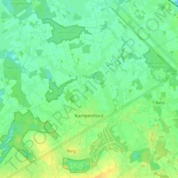
Name: Kampenhout topographic map, elevation, terrain.
Average elevation: 13 m
Minimum elevation: 3 m
Maximum elevation: 25 m
Make a donation
Gear up for your next adventure:
As an Amazon Associate, this site earns from qualifying purchases at no extra cost to you.
Other topographic maps
Click on a map to view its topography, its elevation and its terrain.