
Make a donation
Gear up for your next adventure:
As an Amazon Associate, this site earns from qualifying purchases at no extra cost to you.
Cuetu de la Concilla topographic map
Click on the map to display elevation.
Make a donation
Gear up for your next adventure:
As an Amazon Associate, this site earns from qualifying purchases at no extra cost to you.
Cuetu de la Concilla
Su elevada altitud (1922 metros) y su ventajosa posición, a caballo entre las cuencas de los ríos Nansa y Saja y adelantada hacia el mar respecto a las más altas cumbres, hacen de la Concilla uno de los mejores miradores de toda Cantabria.
Make a donation
Gear up for your next adventure:
As an Amazon Associate, this site earns from qualifying purchases at no extra cost to you.
About this map
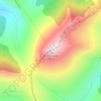
Name: Cuetu de la Concilla topographic map, elevation, terrain.
Location: Cuetu de la Concilla, Polaciones, Cantabria, España (43.09183 -4.34558 43.09193 -4.34548)
Average elevation: 1,489 m
Minimum elevation: 1,115 m
Maximum elevation: 1,907 m
Make a donation
Gear up for your next adventure:
As an Amazon Associate, this site earns from qualifying purchases at no extra cost to you.