
Clyde topographic map
Click on the map to display elevation.
About this map
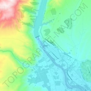
Name: Clyde topographic map, elevation, terrain.
Average elevation: 353 m
Minimum elevation: 136 m
Maximum elevation: 1,046 m
Other topographic maps
Click on a map to view its topography, its elevation and its terrain.
Clyde Dam
New Zealand > Otago > Central Otago District > Vincent Community > Clyde
Average elevation: 318 m
Hawkdun Range
New Zealand > Otago > Central Otago District > Vincent Community
Average elevation: 1,112 m