
Make a donation
Gear up for your next adventure:
As an Amazon Associate, this site earns from qualifying purchases at no extra cost to you.
Mont Vinaigre topographic map
Click on the map to display elevation.
Make a donation
Gear up for your next adventure:
As an Amazon Associate, this site earns from qualifying purchases at no extra cost to you.
Mont Vinaigre
Le mont Vinaigre est le point culminant du massif de l'Esterel. Il culmine à 614 m d'altitude. Il se trouve sur la commune de Fréjus. Il dispose d'un héliport sous son sommet.
Make a donation
Gear up for your next adventure:
As an Amazon Associate, this site earns from qualifying purchases at no extra cost to you.
About this map
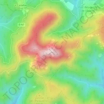
Name: Mont Vinaigre topographic map, elevation, terrain.
Average elevation: 342 m
Minimum elevation: 162 m
Maximum elevation: 591 m
Make a donation
Gear up for your next adventure:
As an Amazon Associate, this site earns from qualifying purchases at no extra cost to you.
Other topographic maps
Click on a map to view its topography, its elevation and its terrain.
Make a donation
Gear up for your next adventure:
As an Amazon Associate, this site earns from qualifying purchases at no extra cost to you.