Geolocate

Boyd topographic map

Click on the map to display elevation.

About this map

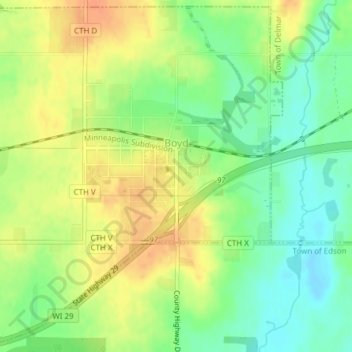
Name: Boyd topographic map, elevation, terrain.

Location: Boyd, Chippewa County, Wisconsin, United States (44.93636 -91.05538 44.96236 -91.02337)

Average elevation: 336 m

Minimum elevation: 317 m

Maximum elevation: 354 m

Other topographic maps

Click on a map to view its topography, its elevation and its terrain.

Jim Falls

United States > Wisconsin > Chippewa County

Average elevation: 297 m

Colburn

United States > Wisconsin > Chippewa County > Colburn

Average elevation: 343 m

Holcombe

United States > Wisconsin > Chippewa County

Average elevation: 325 m

Arnold

United States > Wisconsin > Chippewa County > Arnold

Average elevation: 343 m

Gear up for your next adventure:

Lightweight Backpacking Tent - Compact tent for efficient hiking trips
🧼Travel Hand Sanitizer - Keep hands clean when water is scarce
🛶Waterproof Dry Bags - Keep electronics and clothes dry during river crossings
👖Convertible Hiking Pants - Zip-off legs to adapt to changing weather conditions
🧴Waterproofing Spray - Restore the DWR coating on jackets and tents

As an Amazon Associate, this site earns from qualifying purchases at no extra cost to you.