
Scheyern topographic map
Click on the map to display elevation.
Scheyern
Im Jahre 2018 gab es nach der amtlichen Statistik in der Gemeinde 688 sozialversicherungspflichtig Beschäftigte am Arbeitsort. Von der Wohnbevölkerung standen 2028 Personen in einem versicherungspflichtigen Arbeitsverhältnis. Die Zahl der Auspendler war damit um 1340 höher als die der Einpendler. 41 Einwohner waren arbeitslos. 2016 gab es 72 landwirtschaftliche Betriebe, die eine Fläche von 2228 Hektar bewirtschafteten.
About this map
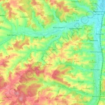
Name: Scheyern topographic map, elevation, terrain.
Average elevation: 473 m
Minimum elevation: 421 m
Maximum elevation: 534 m
Other topographic maps
Click on a map to view its topography, its elevation and its terrain.
Straßhöfe
Deutschland > Bayern > Landkreis Pfaffenhofen an der Ilm > Rohrbach an der Ilm
Average elevation: 426 m
Holzleiten
Deutschland > Bayern > Landkreis Pfaffenhofen an der Ilm > Geisenfeld
Average elevation: 386 m
Gotteshofen
Deutschland > Bayern > Landkreis Pfaffenhofen an der Ilm > Reichertshofen > Reichertshofen
Average elevation: 388 m
Pleiling
Deutschland > Bayern > Landkreis Pfaffenhofen an der Ilm > Vohburg an der Donau > Pleiling
Average elevation: 400 m
Untermettenbach
Deutschland > Bayern > Landkreis Pfaffenhofen an der Ilm > Geisenfeld > Untermettenbach
Average elevation: 420 m
Fahlenbach
Deutschland > Bayern > Landkreis Pfaffenhofen an der Ilm > Rohrbach
Average elevation: 412 m
Weingarten
Deutschland > Bayern > Landkreis Pfaffenhofen an der Ilm > Pfaffenhofen an der Ilm > Haimpertshofen
Average elevation: 451 m
Fürholzen
Deutschland > Bayern > Landkreis Pfaffenhofen an der Ilm > Rohrbach
Average elevation: 432 m
Haimpertshofen
Deutschland > Bayern > Landkreis Pfaffenhofen an der Ilm > Pfaffenhofen an der Ilm
Average elevation: 448 m
Eichelberg
Deutschland > Bayern > Landkreis Pfaffenhofen an der Ilm > Geisenfeld
Average elevation: 402 m
Engelbrechtsmünster
Deutschland > Bayern > Landkreis Pfaffenhofen an der Ilm > Geisenfeld
Average elevation: 383 m
Siebeneichmühle
Deutschland > Bayern > Landkreis Pfaffenhofen an der Ilm > Pfaffenhofen an der Ilm > Affalterbach
Average elevation: 440 m
Wasenstatt
Deutschland > Bayern > Landkreis Pfaffenhofen an der Ilm > Pfaffenhofen an der Ilm > Göbelsbach
Average elevation: 451 m
Gambach
Deutschland > Bayern > Landkreis Pfaffenhofen an der Ilm > Rohrbach an der Ilm
Average elevation: 440 m
Hög
Deutschland > Bayern > Landkreis Pfaffenhofen an der Ilm > Reichertshofen
Average elevation: 410 m
Tegernbach
Deutschland > Bayern > Landkreis Pfaffenhofen an der Ilm > Pfaffenhofen an der Ilm > Tegernbach
Average elevation: 458 m
Knodorf
Deutschland > Bayern > Landkreis Pfaffenhofen an der Ilm > Vohburg an der Donau
Average elevation: 360 m
Rottenegg
Deutschland > Bayern > Landkreis Pfaffenhofen an der Ilm > Geisenfeld
Average elevation: 439 m
Affalterbach
Deutschland > Bayern > Landkreis Pfaffenhofen an der Ilm > Pfaffenhofen an der Ilm > Affalterbach
Average elevation: 439 m
Siebeneich
Deutschland > Bayern > Landkreis Pfaffenhofen an der Ilm > Kohlstatt > Siebeneich
Average elevation: 497 m
Jebertshausen
Deutschland > Bayern > Landkreis Pfaffenhofen an der Ilm > Wolnzach > Jebertshausen
Average elevation: 449 m
Egg
Deutschland > Bayern > Landkreis Pfaffenhofen an der Ilm > Wolnzach > Egg
Average elevation: 482 m
Sankt Kastl
Deutschland > Bayern > Landkreis Pfaffenhofen an der Ilm > Stöffel > Sankt Kastl
Average elevation: 432 m
Hagberg
Deutschland > Bayern > Landkreis Pfaffenhofen an der Ilm > Hettenshausen
Average elevation: 453 m
Oberhartheim
Deutschland > Bayern > Landkreis Pfaffenhofen an der Ilm > Vohburg an der Donau
Average elevation: 394 m
Rottenegg
Deutschland > Bayern > Landkreis Pfaffenhofen an der Ilm > Geisenfeld
Average elevation: 439 m