
Make a donation
Gear up for your next adventure:
As an Amazon Associate, this site earns from qualifying purchases at no extra cost to you.
La Haye topographic map
Click on the map to display elevation.
Make a donation
Gear up for your next adventure:
As an Amazon Associate, this site earns from qualifying purchases at no extra cost to you.
About this map
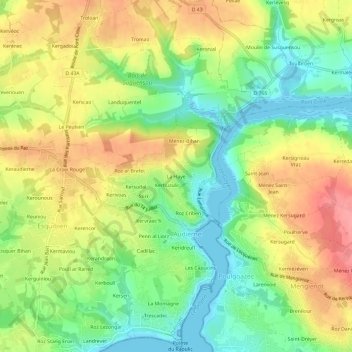
Name: La Haye topographic map, elevation, terrain.
Average elevation: 41 m
Minimum elevation: -3 m
Maximum elevation: 87 m
Make a donation
Gear up for your next adventure:
As an Amazon Associate, this site earns from qualifying purchases at no extra cost to you.
Other topographic maps
Click on a map to view its topography, its elevation and its terrain.
Audierne
France > Bretagne > Finistère > Audierne
La commune d'Audierne (avant la fusion avec Esquibien) était de petite superficie (295 hectares) : riveraine au sud de l'Océan Atlantique (Baie d'Audierne) et à l'est de la ria du Goyen, la commune était limitée au nord et à l'ouest par la seule commune d'Esquibien. Son finage était en pente forte,…
Average elevation: 34 m