
Make a donation
Gear up for your next adventure:
As an Amazon Associate, this site earns from qualifying purchases at no extra cost to you.
Woodbury topographic map
Click on the map to display elevation.
Make a donation
Gear up for your next adventure:
As an Amazon Associate, this site earns from qualifying purchases at no extra cost to you.
About this map
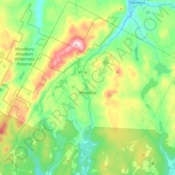
Name: Woodbury topographic map, elevation, terrain.
Location: Woodbury, Washington County, Vermont, 05681, United States (44.38435 -72.49324 44.50524 -72.32139)
Average elevation: 411 m
Minimum elevation: 245 m
Maximum elevation: 741 m
Make a donation
Gear up for your next adventure:
As an Amazon Associate, this site earns from qualifying purchases at no extra cost to you.
Other topographic maps
Click on a map to view its topography, its elevation and its terrain.
Make a donation
Gear up for your next adventure:
As an Amazon Associate, this site earns from qualifying purchases at no extra cost to you.
North Montpelier
United States > Vermont > Washington County > East Montpelier
Average elevation: 278 m