
Make a donation
Gear up for your next adventure:
As an Amazon Associate, this site earns from qualifying purchases at no extra cost to you.
Port Jefferson Harbor topographic map
Click on the map to display elevation.
Make a donation
Gear up for your next adventure:
As an Amazon Associate, this site earns from qualifying purchases at no extra cost to you.
About this map
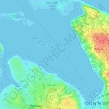
Name: Port Jefferson Harbor topographic map, elevation, terrain.
Average elevation: 10 m
Minimum elevation: -4 m
Maximum elevation: 56 m
Make a donation
Gear up for your next adventure:
As an Amazon Associate, this site earns from qualifying purchases at no extra cost to you.
Other topographic maps
Click on a map to view its topography, its elevation and its terrain.
Stony Brook University
United States > New York > Suffolk County > Town of Brookhaven
Average elevation: 46 m
Make a donation
Gear up for your next adventure:
As an Amazon Associate, this site earns from qualifying purchases at no extra cost to you.
Village of Belle Terre
United States > New York > Suffolk County > Town of Brookhaven
Average elevation: 20 m
Middle Island
United States > New York > Suffolk County > Town of Brookhaven
On October 27, 1910, the International Aviation Tournament was held at the Belmont Park racetrack in Elmont, New York. The meet offered $3,750 for the highest altitude, another $1,000 for a world record and a $5,000 bonus for exceeding 10,000 feet. Ralph Johnstone set a new American flight altitude record of…
Average elevation: 31 m