
Make a donation
Gear up for your next adventure:
As an Amazon Associate, this site earns from qualifying purchases at no extra cost to you.
Velpen topographic map
Click on the map to display elevation.
Make a donation
Gear up for your next adventure:
As an Amazon Associate, this site earns from qualifying purchases at no extra cost to you.
About this map
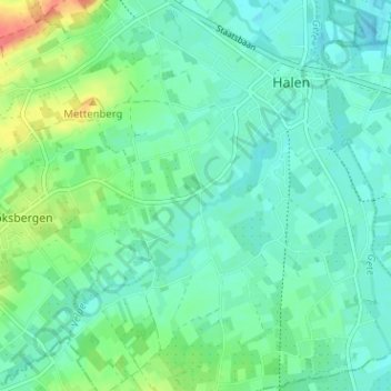
Name: Velpen topographic map, elevation, terrain.
Location: Velpen, Halen, Hasselt, Limburg, 3545, België (50.91627 5.07869 50.95627 5.11869)
Average elevation: 30 m
Minimum elevation: 17 m
Maximum elevation: 68 m
Make a donation
Gear up for your next adventure:
As an Amazon Associate, this site earns from qualifying purchases at no extra cost to you.
Other topographic maps
Click on a map to view its topography, its elevation and its terrain.
Halen
België > Limburg > Hasselt > Halen
Halen ligt op de grens van Haspengouw en Hageland. De gemeente ligt aan de Velpe en de samenvloeiing van de Demer en de Gete. De Velpe mondt in Zelk in de Demer. Iets voor de monding van de Gete komt de Herk uit in de Gete. Ook de (gekanaliseerde) Melsterbeek komt op de grens met Donk ter hoogte van Halen in…
Average elevation: 30 m