
Make a donation
Gear up for your next adventure:
As an Amazon Associate, this site earns from qualifying purchases at no extra cost to you.
Villa Minozzo topographic map
Click on the map to display elevation.
Make a donation
Gear up for your next adventure:
As an Amazon Associate, this site earns from qualifying purchases at no extra cost to you.
Villa Minozzo
Its territory includes the ski resort of Febbio and the highest peak in the province, Monte Cusna at 2,121 metres (6,959 ft) above sea level. Through the frazione of Civago and the Forbici Pass, elevation 1,574 metres (5,164 ft), the Garfagana can be reached.
Make a donation
Gear up for your next adventure:
As an Amazon Associate, this site earns from qualifying purchases at no extra cost to you.
About this map
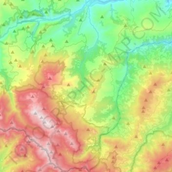
Name: Villa Minozzo topographic map, elevation, terrain.
Average elevation: 1,001 m
Minimum elevation: 350 m
Maximum elevation: 2,087 m
Make a donation
Gear up for your next adventure:
As an Amazon Associate, this site earns from qualifying purchases at no extra cost to you.
Other topographic maps
Click on a map to view its topography, its elevation and its terrain.
Terminaccio
Italy > Emilia-Romagna > Reggio nell'Emilia > Castelnovo ne' Monti > Garfagnolo
Average elevation: 706 m
Make a donation
Gear up for your next adventure:
As an Amazon Associate, this site earns from qualifying purchases at no extra cost to you.
Make a donation
Gear up for your next adventure:
As an Amazon Associate, this site earns from qualifying purchases at no extra cost to you.