
Make a donation
Gear up for your next adventure:
As an Amazon Associate, this site earns from qualifying purchases at no extra cost to you.
Leutzdorf topographic map
Click on the map to display elevation.
Make a donation
Gear up for your next adventure:
As an Amazon Associate, this site earns from qualifying purchases at no extra cost to you.
Leutzdorf
Allersdorf | Altenthal | Behringersmühle | Bösenbirkig | Etzdorf | Geiselhöhe | Gößweinstein | Hardt | Hartenreuth | Hühnerloh | Hungenberg | Kleingesee | Kohlstein | Leimersberg | Leutzdorf | Liebenau | Moritz | Morschreuth | Moschendorf | Prügeldorf | Sachsendorf | Sachsendorf-Straßhüll | Sachsenmühle | Sattelmannsburg | Schweigelberg | Stadelhofen | Stempfermühle | Türkelstein | Ühleinshof | Unterailsfeld | Wichsenstein | Wölm
Make a donation
Gear up for your next adventure:
As an Amazon Associate, this site earns from qualifying purchases at no extra cost to you.
About this map
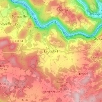
Name: Leutzdorf topographic map, elevation, terrain.
Average elevation: 458 m
Minimum elevation: 310 m
Maximum elevation: 551 m
Make a donation
Gear up for your next adventure:
As an Amazon Associate, this site earns from qualifying purchases at no extra cost to you.
Other topographic maps
Click on a map to view its topography, its elevation and its terrain.
91327
Deutschland > Bayern > Landkreis Forchheim > Gößweinstein > Behringersmühle > Stempfermühle
Average elevation: 461 m