Geolocate

Cortina topographic map

Click on the map to display elevation.

About this map

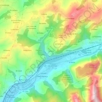
Name: Cortina topographic map, elevation, terrain.

Location: Cortina, Oviedo, Asturias, 33919, Spain (43.30975 -5.81708 43.34975 -5.77708)

Average elevation: 309 m

Minimum elevation: 144 m

Maximum elevation: 553 m

Other topographic maps

Click on a map to view its topography, its elevation and its terrain.

Naranco

Spain > Asturias > Oviedo

Average elevation: 351 m

Anieves

Spain > Asturias > Oviedo > Anieves

Average elevation: 282 m

Gear up for your next adventure:

Lightweight Backpacking Tent - Compact tent for efficient hiking trips
🥾Mountaineering Boots - Supportive boots for climbing and high-altitude hiking
🎒Hiking Daypack - Lightweight and durable backpacks for day trips and excursions
🥽Outdoor Goggles - Protective eyewear for outdoor activities
🧤Insulated Winter Gloves - Heavy-duty protection for sub-zero Canadian adventures

As an Amazon Associate, this site earns from qualifying purchases at no extra cost to you.