Geolocate

San Blas topographic map

Click on the map to display elevation.

About this map

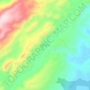
Name: San Blas topographic map, elevation, terrain.

Location: San Blas, Simití, Bolívar, Colombia (7.82426 -74.03599 7.86426 -73.99599)

Average elevation: 229 m

Minimum elevation: 55 m

Maximum elevation: 514 m

Other topographic maps

Click on a map to view its topography, its elevation and its terrain.

Río Boque

Colombia > Bolívar > Simití

Average elevation: 55 m

Gear up for your next adventure:

🥾Waterproof Hiking Shoes - Durable shoes for wet and rugged trails
🥾Lightweight Hiking Shoes - Comfortable shoes for day hikes
🧰Multitool Knife - Compact and versatile tool for outdoor use
🛶Waterproof Dry Bags - Keep electronics and clothes dry during river crossings
🥾Trail Hiking Socks - Comfortable socks to prevent blisters and fatigue

As an Amazon Associate, this site earns from qualifying purchases at no extra cost to you.