
Make a donation
Gear up for your next adventure:
As an Amazon Associate, this site earns from qualifying purchases at no extra cost to you.
Osorno Volcano topographic map
Click on the map to display elevation.
Make a donation
Gear up for your next adventure:
As an Amazon Associate, this site earns from qualifying purchases at no extra cost to you.
Osorno Volcano
The basalt and andesite lava flows generated during these eruptions reached both Lago Llanquihue and Lago Todos Los Santos. All of the upper slopes of Osorno were, until recently, almost entirely covered in glacial ice. However, large areas of glacial retreat have now occurred on the N and W slopes of the volcano. The glaciers were extensive despite its very modest altitude and latitude, sustained by the substantial annual snowfall in the very moist maritime climate of the region. Osorno has also historically produced pyroclastic flow, since it is a composite volcano. The volcano has been noted for its similar appearance to Mount Fuji in Japan.
Make a donation
Gear up for your next adventure:
As an Amazon Associate, this site earns from qualifying purchases at no extra cost to you.
About this map
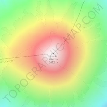
Name: Osorno Volcano topographic map, elevation, terrain.
Average elevation: 1,994 m
Minimum elevation: 1,368 m
Maximum elevation: 2,661 m
Make a donation
Gear up for your next adventure:
As an Amazon Associate, this site earns from qualifying purchases at no extra cost to you.
Other topographic maps
Click on a map to view its topography, its elevation and its terrain.
Todos los Santos Lake
Chile > Los Lagos Region > Provincia de Llanquihue > Puerto Varas
Average elevation: 690 m