
Make a donation
Gear up for your next adventure:
As an Amazon Associate, this site earns from qualifying purchases at no extra cost to you.
Puerto Suárez topographic map
Click on the map to display elevation.
Make a donation
Gear up for your next adventure:
As an Amazon Associate, this site earns from qualifying purchases at no extra cost to you.
Puerto Suárez
La topografía del municipio de Puerto Suárez es relativamente plana caracterizada por zonas de inundación. En cuanto a su fisiografía, se distinguen cuatro paisajes diferentes: serranías, planicies ligeramente disectadas, colinas, llanuras aluviales y llanuras de inundación.
Make a donation
Gear up for your next adventure:
As an Amazon Associate, this site earns from qualifying purchases at no extra cost to you.
About this map
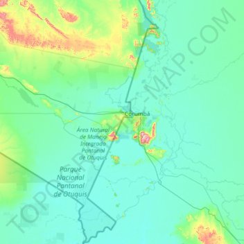
Name: Puerto Suárez topographic map, elevation, terrain.
Location: Puerto Suárez, Germán Busch, Santa Cruz, Bolivia (-20.16712 -59.06893 -17.97913 -57.71420)
Average elevation: 137 m
Minimum elevation: 76 m
Maximum elevation: 1,029 m
Make a donation
Gear up for your next adventure:
As an Amazon Associate, this site earns from qualifying purchases at no extra cost to you.