Geolocate

Lorch topographic map

Click on the map to display elevation.

About this map

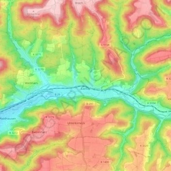
Name: Lorch topographic map, elevation, terrain.

Location: Lorch, Ostalbkreis, Baden-Württemberg, 73547, Germany (48.77034 9.61896 48.82879 9.73135)

Average elevation: 388 m

Minimum elevation: 271 m

Maximum elevation: 505 m

Gear up for your next adventure:

🧣Merino Neck Gaiter - Protects against wind, sun, and cold at high altitudes
🦟Insect Repellent - Keep mosquitoes and black flies away in wooded areas
🧭GPS Outdoor Watch - Smart watch for navigation and fitness tracking in nature
💧Reusable Water Bottle - Durable water bottles for hydration on trails
🥾Approach Boots - Comfortable boots for hiking and climbing approaches

As an Amazon Associate, this site earns from qualifying purchases at no extra cost to you.