
Make a donation
Gear up for your next adventure:
As an Amazon Associate, this site earns from qualifying purchases at no extra cost to you.
Salar de Uyuni topographic map
Click on the map to display elevation.
Make a donation
Gear up for your next adventure:
As an Amazon Associate, this site earns from qualifying purchases at no extra cost to you.
Salar de Uyuni
Salar de Uyuni (or "Salar de Tunupa") is the world's largest salt flat, or playa, at 10,582 square kilometres (4,086 sq mi) in area. It is in the Daniel Campos Province in Potosí in southwest Bolivia, near the crest of the Andes at an elevation of 3,656 m (11,995 ft) above sea level.
Make a donation
Gear up for your next adventure:
As an Amazon Associate, this site earns from qualifying purchases at no extra cost to you.
About this map
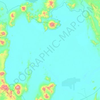
Name: Salar de Uyuni topographic map, elevation, terrain.
Location: Salar de Uyuni, Potosí, Bolivia (-20.72093 -68.27452 -19.68761 -66.90819)
Average elevation: 3,722 m
Minimum elevation: 3,645 m
Maximum elevation: 5,350 m
Make a donation
Gear up for your next adventure:
As an Amazon Associate, this site earns from qualifying purchases at no extra cost to you.
Other topographic maps
Click on a map to view its topography, its elevation and its terrain.
Volcán Licancabur
Bolivia > Potosí > Provincia Sur Lípez > Municipio San Pablo de Lipez
The volcano is in the Puna de Atacama/Cordillera Occidental of the Andes. Politically, it is located in the Antofagasta Region of Chile and the Potosí Department of Bolivia; the border goes over Licancabur. Less than 20 kilometres (12 mi) south is the Llano del Chajnantor Observatory. San Pedro de Atacama is…
Average elevation: 5,285 m