Geolocate

Bandongan topographic map

Click on the map to display elevation.

About this map

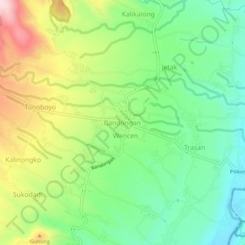
Name: Bandongan topographic map, elevation, terrain.

Location: Bandongan, Magelang, Central Java, Java, 56151, Indonesia (-7.48567 110.16808 -7.44567 110.20808)

Average elevation: 425 m

Minimum elevation: 308 m

Maximum elevation: 617 m

Other topographic maps

Click on a map to view its topography, its elevation and its terrain.

Sungai Progo

Indonesia > Central Java > Magelang > Mungkid

Average elevation: 232 m

Adikarto

Indonesia > Central Java > Magelang > Tanjung

Average elevation: 245 m

Salam

Indonesia > Central Java > Magelang

Average elevation: 284 m

Srumbung

Indonesia > Central Java > Magelang

Average elevation: 764 m

Dukun

Indonesia > Central Java > Magelang

Average elevation: 911 m

Ngluwar

Indonesia > Central Java > Magelang

Average elevation: 242 m

Muntilan

Indonesia > Central Java > Magelang

Average elevation: 296 m

Sawangan

Indonesia > Central Java > Magelang

Average elevation: 1,299 m

Gear up for your next adventure:

🧥Softshell Jacket - Windproof and breathable jacket for hiking
🦶Anti-Blister Balm - Prevents friction and hotspots during long ascents
🔭Compact Monocular - One-handed bird watching and trail spotting
🥾Mountain Hiking Shoes - Shoes with superior grip for mountainous terrain
🧭GPS Outdoor Watch - Smart watch for navigation and fitness tracking in nature

As an Amazon Associate, this site earns from qualifying purchases at no extra cost to you.