Geolocate

Colera topographic map

Click on the map to display elevation.

About this map

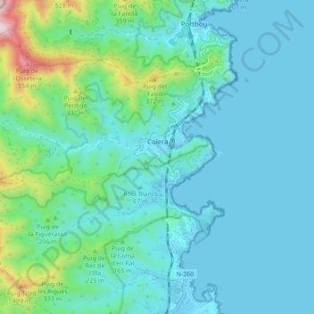
Name: Colera topographic map, elevation, terrain.

Location: Colera, Upper Empordà, Girona, Catalonia, 17496, Spain (42.37442 3.08515 42.42654 3.17095)

Average elevation: 97 m

Minimum elevation: -1 m

Maximum elevation: 609 m

Gear up for your next adventure:

👟Leg Gaiters - Keep debris, mud, and snow out of your boots
💡LED Camping Lantern - Illuminate your campsite with long-lasting lanterns
🧤Thermal Hiking Gloves - Grip-enhanced gloves for cold-weather altitude trekking
🏕️Camping Hammock - Integrated protection for sleeping between trees
🌬️Windproof Camp Stove - Efficient cooking even on exposed mountain peaks

As an Amazon Associate, this site earns from qualifying purchases at no extra cost to you.