Geolocate

Frasco topographic map

Click on the map to display elevation.

Frasco

The village is located in the Locarno district. It consists of the village of Frasco and multiple scattered settlements along the road in the upper Verzasca valley. The average elevation of the settlements is about 880 meters (2,890 ft).

Wikipedia (CC-BY-SA 3.0)

About this map

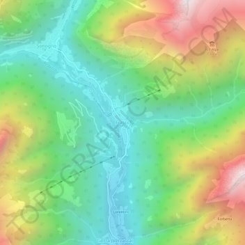
Name: Frasco topographic map, elevation, terrain.

Location: Frasco, Verzasca, Circolo della Verzasca, Distretto di Locarno, Ticino, 6636, Switzerland (46.31776 8.78436 46.35776 8.82436)

Average elevation: 1,393 m

Minimum elevation: 794 m

Maximum elevation: 2,450 m

Gear up for your next adventure:

🛶Kayak Accessories - Essential gear for safe and fun kayaking adventures
Camping Essentials - All-in-one gear for a comfortable camping trip
🧣Evaporative Cooling Towel - Beat the heat during intense summer climbs
🥾Approach Boots - Comfortable boots for hiking and climbing approaches
🗺️Topographic Maps - Detailed maps to explore trails, mountains, and wilderness areas

As an Amazon Associate, this site earns from qualifying purchases at no extra cost to you.