Geolocate

Tabernilla topographic map

Click on the map to display elevation.

About this map

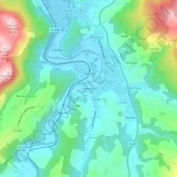
Name: Tabernilla topographic map, elevation, terrain.

Location: Tabernilla, Ampuero, Cantabria, 39849, España (43.32238 -3.44136 43.36238 -3.40136)

Average elevation: 122 m

Minimum elevation: -1 m

Maximum elevation: 493 m

Gear up for your next adventure:

🥾Mountain Hiking Shoes - Shoes with superior grip for mountainous terrain
🥾Waterproof Hiking Shoes - Durable shoes for wet and rugged trails
🧢Beanie Hat - Keep your head warm in cold weather
Tent Footprint - Protect tent floor and increase durability
🗺️Topographic Maps - Detailed maps to explore trails, mountains, and wilderness areas

As an Amazon Associate, this site earns from qualifying purchases at no extra cost to you.