
Make a donation
Gear up for your next adventure:
As an Amazon Associate, this site earns from qualifying purchases at no extra cost to you.
Talampaya National Park topographic map
Click on the map to display elevation.
Make a donation
Gear up for your next adventure:
As an Amazon Associate, this site earns from qualifying purchases at no extra cost to you.
Talampaya National Park
The park protects an area of the High Monte ecoregion. The park covers an area of 2,150 square kilometres (830 sq mi), at an altitude of 1,500 metres (4,921 ft) above mean sea level. Its purpose is to protect important archaeological and palaeontological sites found in the area. It has landscapes of great beauty, with flora and fauna typical of the mountain biome.
Make a donation
Gear up for your next adventure:
As an Amazon Associate, this site earns from qualifying purchases at no extra cost to you.
About this map
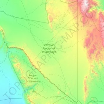
Name: Talampaya National Park topographic map, elevation, terrain.
Average elevation: 1,449 m
Minimum elevation: 767 m
Maximum elevation: 3,381 m
Make a donation
Gear up for your next adventure:
As an Amazon Associate, this site earns from qualifying purchases at no extra cost to you.
Other topographic maps
Click on a map to view its topography, its elevation and its terrain.
Make a donation
Gear up for your next adventure:
As an Amazon Associate, this site earns from qualifying purchases at no extra cost to you.