
Make a donation
Gear up for your next adventure:
As an Amazon Associate, this site earns from qualifying purchases at no extra cost to you.
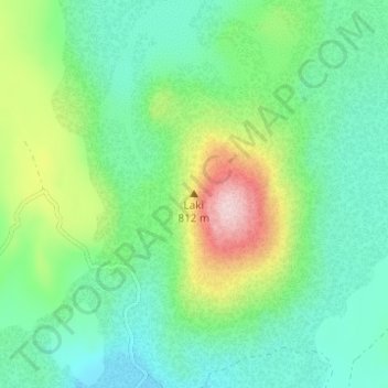
Laki topographic map
Click on the map to display elevation.
Make a donation
Gear up for your next adventure:
As an Amazon Associate, this site earns from qualifying purchases at no extra cost to you.
Laki
The eruption, also known as the Skaftáreldar [ˈskaftˌauːrˌɛltar̥] ("Skaftá fires") or Síðueldur [ˈsiːðʏˌɛltʏr̥] produced an estimated 14 km3 (18×10^9 cu yd) of basalt lava, and the total volume of tephra emitted was 0.91 km3 (1.2×10^9 cu yd). Lava fountains were estimated to have reached heights of 800 to 1,400 m (2,600 to 4,600 ft). The gases were carried by the convective eruption column to altitudes of about 15 km (50,000 ft).
Make a donation
Gear up for your next adventure:
As an Amazon Associate, this site earns from qualifying purchases at no extra cost to you.
About this map
Name: Laki topographic map, elevation, terrain.
Average elevation: 626 m
Minimum elevation: 559 m
Maximum elevation: 793 m
Make a donation
Gear up for your next adventure:
As an Amazon Associate, this site earns from qualifying purchases at no extra cost to you.
Other topographic maps
Click on a map to view its topography, its elevation and its terrain.