
Make a donation
Gear up for your next adventure:
As an Amazon Associate, this site earns from qualifying purchases at no extra cost to you.
Opole topographic map
Click on the map to display elevation.
Make a donation
Gear up for your next adventure:
As an Amazon Associate, this site earns from qualifying purchases at no extra cost to you.
About this map
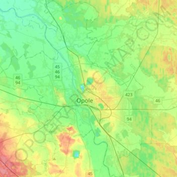
Name: Opole topographic map, elevation, terrain.
Location: Opole, Opole Voivodeship, Poland (50.58762 17.77959 50.76997 18.03269)
Average elevation: 161 m
Minimum elevation: 138 m
Maximum elevation: 207 m
Make a donation
Gear up for your next adventure:
As an Amazon Associate, this site earns from qualifying purchases at no extra cost to you.
Other topographic maps
Click on a map to view its topography, its elevation and its terrain.
Make a donation
Gear up for your next adventure:
As an Amazon Associate, this site earns from qualifying purchases at no extra cost to you.
Góra Świętej Anny
Poland > Opole Voivodeship > Strzelce County > Góra Świętej Anny
Average elevation: 321 m
Strzelce Opolskie
Poland > Opole Voivodeship > Strzelce County > Strzelce Opolskie > Strzelce Opolskie
Average elevation: 238 m
Make a donation
Gear up for your next adventure:
As an Amazon Associate, this site earns from qualifying purchases at no extra cost to you.