
Thank you for supporting this site ❤️
Make a donation
Make a donation
Gear up for your next adventure:
As an Amazon Associate, this site earns from qualifying purchases at no extra cost to you.
Teleno topographic map
Click on the map to display elevation.
Thank you for supporting this site ❤️
Make a donation
Make a donation
Gear up for your next adventure:
As an Amazon Associate, this site earns from qualifying purchases at no extra cost to you.
About this map
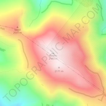
Name: Teleno topographic map, elevation, terrain.
Location: Teleno, Lucillo, León, Castilië en León, Spanje (42.34586 -6.39379 42.34596 -6.39369)
Average elevation: 1,905 m
Minimum elevation: 1,544 m
Maximum elevation: 2,174 m
Thank you for supporting this site ❤️
Make a donation
Make a donation
Gear up for your next adventure:
As an Amazon Associate, this site earns from qualifying purchases at no extra cost to you.