Geolocate

Miramar topographic map

Click on the map to display elevation.

About this map

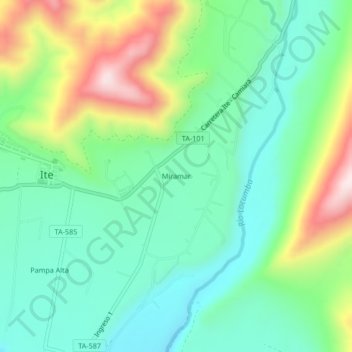
Name: Miramar topographic map, elevation, terrain.

Location: Miramar, Ite, Jorge Basadre, Tacna, Perú (-17.88156 -70.96985 -17.84156 -70.92985)

Average elevation: 212 m

Minimum elevation: 59 m

Maximum elevation: 545 m

Other topographic maps

Click on a map to view its topography, its elevation and its terrain.

Humedales de Ite

Perú > Tacna > Ite

Average elevation: 51 m

Humedales de Ite

Perú > Tacna > Ite

Average elevation: 51 m

Gear up for your next adventure:

🌡️Emergency Mylar Blankets - Compact thermal protection for unexpected nights outdoors
🔋Solar Power Bank - Keep your GPS and devices charged during long outdoor trips
🔭Outdoor Binoculars - Lightweight binoculars for birdwatching and hiking
🛰️Satellite Messenger - Emergency communication for areas with no cell service
🧤Insulated Winter Gloves - Heavy-duty protection for sub-zero Canadian adventures

As an Amazon Associate, this site earns from qualifying purchases at no extra cost to you.