Geolocate

Assen topographic map

Click on the map to display elevation.

About this map

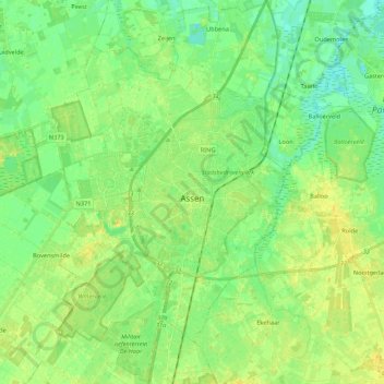
Name: Assen topographic map, elevation, terrain.

Location: Assen, Drenthe, Netherlands (52.93251 6.48395 53.06192 6.63265)

Average elevation: 12 m

Minimum elevation: 3 m

Maximum elevation: 22 m

Other topographic maps

Click on a map to view its topography, its elevation and its terrain.

Lhee

Netherlands > Drenthe

Average elevation: 11 m

Hondsrug

Netherlands > Drenthe > Exloo

Average elevation: 19 m

Zuidbarge

Netherlands > Drenthe > Emmen

Average elevation: 20 m

Gear up for your next adventure:

🎒Hiking Backpack - Lightweight and ergonomic backpacks for day hikes or multi-day treks
Camping Tent - Weather-resistant tents suitable for 2 to 6 people
🎒Hiking Daypack - Lightweight and durable backpacks for day trips and excursions
🧥Packable Rain Jacket - Breathable waterproof layer for unpredictable weather
🧼Biodegradable Camp Soap - Environmentally friendly cleaning for gear and body

As an Amazon Associate, this site earns from qualifying purchases at no extra cost to you.