
Clyde topographic map
Click on the map to display elevation.
About this map
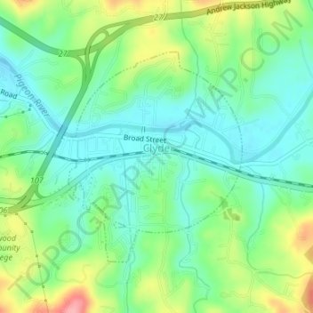
Name: Clyde topographic map, elevation, terrain.
Location: Clyde, Haywood County, North Carolina, United States (35.52356 -82.92156 35.54172 -82.90160)
Average elevation: 802 m
Minimum elevation: 764 m
Maximum elevation: 880 m
Other topographic maps
Click on a map to view its topography, its elevation and its terrain.
Cataloochee Valley Viewpoint
United States > North Carolina > Haywood County > Cataloochee
Average elevation: 1,058 m
Panther Creek
United States > North Carolina > Haywood County > Panther Creek
Average elevation: 873 m