Geolocate

Dyesville topographic map

Click on the map to display elevation.

About this map

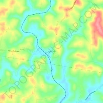
Name: Dyesville topographic map, elevation, terrain.

Location: Dyesville, Meigs County, Ohio, United States (39.10813 -82.24987 39.14813 -82.20987)

Average elevation: 218 m

Minimum elevation: 179 m

Maximum elevation: 275 m

Other topographic maps

Click on a map to view its topography, its elevation and its terrain.

Racine

United States > Ohio > Meigs County

Average elevation: 185 m

Middleport

United States > Ohio > Meigs County > Middleport

Average elevation: 205 m

Rutland

United States > Ohio > Meigs County > Rutland

Average elevation: 202 m

Gear up for your next adventure:

🎒Hiking Daypack - Lightweight and durable backpacks for day trips and excursions
🧤Insulated Winter Gloves - Heavy-duty protection for sub-zero Canadian adventures
🧴Insect Repellent - Protect yourself from bugs during outdoor adventures
🐕Hiking Dog Pack - Let your canine companion carry their own water and food
🧥Softshell Hiking Jacket - The perfect balance of wind protection and breathability

As an Amazon Associate, this site earns from qualifying purchases at no extra cost to you.