
Make a donation
Gear up for your next adventure:
As an Amazon Associate, this site earns from qualifying purchases at no extra cost to you.
Belfeiro topographic map
Click on the map to display elevation.
Make a donation
Gear up for your next adventure:
As an Amazon Associate, this site earns from qualifying purchases at no extra cost to you.
About this map
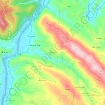
Name: Belfeiro topographic map, elevation, terrain.
Location: Belfeiro, Penacova, Coimbra, 3360-192, Portugal (40.25010 -8.27605 40.29010 -8.23605)
Average elevation: 165 m
Minimum elevation: 28 m
Maximum elevation: 352 m
Make a donation
Gear up for your next adventure:
As an Amazon Associate, this site earns from qualifying purchases at no extra cost to you.
Other topographic maps
Click on a map to view its topography, its elevation and its terrain.
Figueira de Lorvão
Foi então que lhe veio veio à mente a ideia de que seria algo mais: “No cimo daquele monte com despenhadeiro para nascente e sul – topografia escolhida pelos castelos medievais – era possível que ali tivesse construído uma Pousada algum dos Reis de Portugal.”
Average elevation: 270 m