Geolocate

West Concord topographic map

Click on the map to display elevation.

About this map
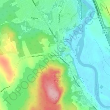
Name: West Concord topographic map, elevation, terrain.

Location: West Concord, Concord, Merrimack County, New Hampshire, 03301, United States (43.22369 -71.59285 43.26369 -71.55285)

Average elevation: 118 m

Minimum elevation: 66 m

Maximum elevation: 234 m

Other topographic maps

Click on a map to view its topography, its elevation and its terrain.
Gear up for your next adventure:

🕶️Polarized Sunglasses - Protect your eyes with durable polarized lenses
🧣Evaporative Cooling Towel - Beat the heat during intense summer climbs
⛺Camping Essentials - All-in-one gear for a comfortable camping trip
🥾Trail Running Shoes - Lightweight and durable shoes for trail running
🔋Emergency Crank Radio - Weather alerts and power without needing batteries

As an Amazon Associate, this site earns from qualifying purchases at no extra cost to you.