Geolocate

Cancún topographic map

Click on the map to display elevation.

About this map

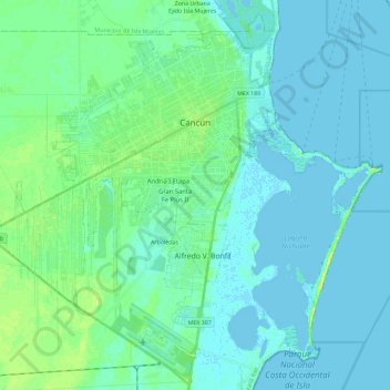
Name: Cancún topographic map, elevation, terrain.

Location: Cancún, Benito Juárez, Quintana Roo, Mexico (21.02976 -86.97121 21.21303 -86.74054)

Average elevation: 5 m

Minimum elevation: -4 m

Maximum elevation: 21 m

Other topographic maps

Click on a map to view its topography, its elevation and its terrain.

Lagos del Sol

Mexico > Quintana Roo > Benito Juárez

Average elevation: 4 m

Gear up for your next adventure:

🧶550 Survival Paracord - Versatile utility cord for emergency repairs and rigging
💧Reusable Water Bottle - Durable water bottles for hydration on trails
🦯Trekking Poles - Reduced impact on joints for steep topographic climbs
🧴Outdoor Sunscreen - High SPF protection for high-altitude UV exposure
🥾Trail Running Shoes - Lightweight and durable shoes for trail running

As an Amazon Associate, this site earns from qualifying purchases at no extra cost to you.