Besançon topographic map
Click on the map to display elevation.
Besançon
The city initially developed in a natural meander (or oxbow loop) of the river Doubs with a diameter of almost 1,000 metres (3,281 feet). The flat inner loop has an elevation of about 250 metres (820 feet), and is bounded to the south by a hill called Mont Saint-Étienne, which has a maximum height of 371 metres (1,217 feet). The city is surrounded by six other hills which range in elevation from 400 to 500 metres (1,312 to 1,640 feet): Brégille, Griffon, Planoise, Chaudanne, Montfaucon, and Montboucon. (There is a barge canal that cuts through rock under Mont Saint-Étienne, short-cutting the meander.)
About this map
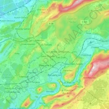
Name: Besançon topographic map, elevation, terrain.
Average elevation: 332 m
Minimum elevation: 217 m
Maximum elevation: 608 m
Other topographic maps
Click on a map to view its topography, its elevation and its terrain.
La Corvée de Goux
France > Bourgogne – Franche-Comté > Doubs > Vercel-Villedieu-le-Camp
Average elevation: 691 m