
Notre Dame Mountains topographic map
Interactive map
Click on the map to display elevation.
About this map
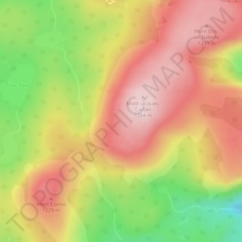
Name: Notre Dame Mountains topographic map, elevation, terrain.
Average elevation: 1,128 m
Minimum elevation: 925 m
Maximum elevation: 1,276 m
Other topographic maps
Click on a map to view its topography, its elevation and its terrain.
Mont Xalibu
Canada > Quebec > Mont-Albert
Mont Xalibu, Mont-Albert, La Haute-Gaspésie, Gaspésie–Îles-de-la-Madeleine, Quebec, Canada
Average elevation: 916 m
Mont Jacques-Cartier
Canada > Quebec > Mont-Albert
Mont Jacques-Cartier, Mont-Albert, La Haute-Gaspésie, Gaspésie–Îles-de-la-Madeleine, Quebec, Canada
Average elevation: 1,137 m