Geolocate

Salakaria topographic map

Click on the map to display elevation.

About this map

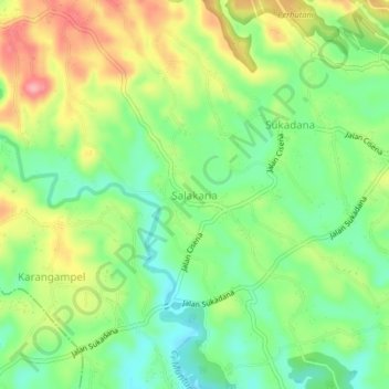
Name: Salakaria topographic map, elevation, terrain.

Location: Salakaria, Ciamis, West Java, Java, 46272, Indonesia (-7.28906 108.40227 -7.24906 108.44227)

Average elevation: 193 m

Minimum elevation: 145 m

Maximum elevation: 261 m

Other topographic maps

Click on a map to view its topography, its elevation and its terrain.

Linggasari

Indonesia > West Java > Ciamis > Ciamis

Average elevation: 218 m

Ciamis

Indonesia > West Java > Ciamis

Ciamis Regency consists of 328 villages, with the topography predominantly characterized by 153 villages in the plains, 162 villages on the slopes, and 13 villages in the Watershed (DAS) area.

Average elevation: 217 m

Cikoneng

Indonesia > West Java > Ciamis

Average elevation: 492 m

Bojongmengger

Indonesia > West Java > Ciamis

Average elevation: 118 m

Gear up for your next adventure:

🧢Sun Hat - Wide-brim hat for sun protection
🧴Sunscreen SPF - Broad-spectrum sunscreen for outdoor activities
🧥Softshell Jacket - Windproof and breathable jacket for hiking
🧥Thermal Layer - Insulating layer for cold outdoor conditions
🚲MTB Frame Bag - Carry tools and maps directly on your bicycle frame

As an Amazon Associate, this site earns from qualifying purchases at no extra cost to you.