Geolocate

Santa Croce topographic map

Click on the map to display elevation.

About this map

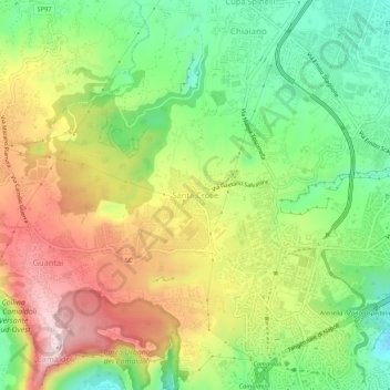
Name: Santa Croce topographic map, elevation, terrain.

Location: Santa Croce, Naples, Campania, 80131, Italy (40.85368 14.19120 40.89368 14.23120)

Average elevation: 251 m

Minimum elevation: 84 m

Maximum elevation: 457 m

Other topographic maps

Click on a map to view its topography, its elevation and its terrain.

Isola la Gaiola

Italy > Campania > Naples > Naples > Coroglio

Average elevation: 19 m

Gear up for your next adventure:

🔭Outdoor Binoculars - Lightweight binoculars for birdwatching and hiking
Camping Essentials - All-in-one gear for a comfortable camping trip
🥾Light Hiking Boots - Lightweight and comfortable boots for day hikes
🥾Mountain Trail Shoes - High-traction shoes for mountain trails
🧦Hiking Liner Socks - Thin base layer to prevent friction and blisters

As an Amazon Associate, this site earns from qualifying purchases at no extra cost to you.