
Thank you for supporting this site ❤️
Make a donation
Make a donation
Gear up for your next adventure:
As an Amazon Associate, this site earns from qualifying purchases at no extra cost to you.
Calumpang topographic map
Click on the map to display elevation.
Thank you for supporting this site ❤️
Make a donation
Make a donation
Gear up for your next adventure:
As an Amazon Associate, this site earns from qualifying purchases at no extra cost to you.
About this map
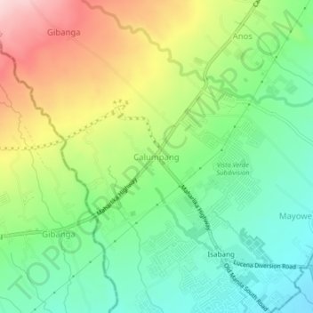
Name: Calumpang topographic map, elevation, terrain.
Location: Calumpang, Tayabas, Quezon, Calabarzon, 4327, Philippines (13.95589 121.53687 13.99589 121.57687)
Average elevation: 193 m
Minimum elevation: 84 m
Maximum elevation: 367 m
Thank you for supporting this site ❤️
Make a donation
Make a donation
Gear up for your next adventure:
As an Amazon Associate, this site earns from qualifying purchases at no extra cost to you.